Before There Was Wrinkle Point…
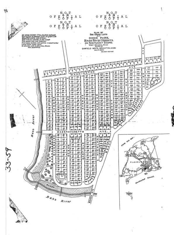
So we all know that Jack Davenport developed Wrinkle Point in the late 1950s and early 1960s. But before that, the Garfield Brothers of Brockton actually owned all of what we now know is Wrinkle Point. But they called it Ocean Park, Bass River Heights. In fact, in 1894 they had laid out a plot plan for over 300 lots.
The lots were very small, about 4,000 square feet, and the street names were different. Click to see a full-size map in a new browser window.
Uncle Barney’s Road turned into Riverside Avenue. Davenport was Washington Avenue, and Massachusetts Avenue cut through the middle of Wrinkle Point!
Palmer’s Circle was planned to be a park with two boat landings, & at the end of Riverside Avenue (now Uncle Barney’s Road) they had planned a hotel.
Maybe the Garfield brother’s plan never succeeded because of the Panic of 1893 when there was a run on banks and a subsequent credit crunch. But just imagine what Wrinkle Point would look like today if they had succeeded.
Though I do wonder why they didn’t call it Wrinkle Point, but that’s a topic for a future blog!